abstract:
Domestically, yesterday, the precipitation in most parts of the country was weak, and some parts of Yunnan experienced small to moderate rain. It is predicted that there will be rainy and snowy weather in southwest China and eastern Tibet in the next three days, and attention will be paid to the impact on Spring Festival travel rush and energy supply.
Globally, there was strong rain and snow in Eastern Europe and the western United States yesterday. In the next three days, there will be strong snowfall in northern Europe and the northeastern United States; The high temperature in western Australia weakened and the central part developed.
I. Domestic weather conditions
1. Reality
Most of the country’s precipitation is weak, and there is little to moderate rain in Yunnan: from 8 o’clock yesterday to 6 o’clock, most of the country’s precipitation is weak, and rainfall (snow) or sleet is 1 ~ 5 mm in parts of Sichuan Basin and western Guizhou; Small to moderate rain occurred in most parts of Yunnan, with heavy rain (25 ~ 41 mm) in Xishuangbanna; There is freezing rain in the western part of Guizhou. At 5 o’clock today, compared with 5 o’clock yesterday, the temperature in most parts of the central and eastern regions rose by 2 ~ 8 C; This morning, the temperature 0℃ line is located in southern Zhejiang, northwestern Jiangxi and northern Hubei.
2. Key weather forecast
Rainy and snowy weather in southwest China
In the next three days, there will be small to medium snow or sleet in parts of eastern and southern Tibet, western Sichuan Plateau, Guizhou and northern Yunnan, and freezing rain in western Guizhou; Some areas in Yunnan, Guangxi and other places have small to moderate rain.
From 29th to 30th, there was light rain or sleet in Jianghan, Jianghuai, Guizhou and northwestern Hunan, and moderate to heavy rain and local heavy rain in most parts of the south of the Yangtze River and southern China. From 31st to 2nd February, there will be a large-scale rain and snow weather process in the central and eastern regions. There is snowfall in the eastern part of northwest China, north China and northeast China, sleet in the west of Jianghan, the west and north of Huanghuai, moderate to heavy rain in the south and most of the south of Huanghuai, and heavy rain in some parts of Jiangnan and South China.
Second, the global weather situation
1. Reality
Strong rain and snow occurred in eastern Europe and the western United States: in the past 24 hours, moderate to heavy snow and local snowstorms occurred in parts of eastern Europe, western and northern eastern Europe, southern Caucasus, central Asia, north-central western Siberia, western Russian Far East, eastern United States and the Great Lakes region; Heavy rains occurred in the Brazilian Plateau, southern Central Africa, southern East Africa, northern Madagascar, eastern Indonesia, northern Australia, south-central United States and other places, and local heavy rains occurred.
2. Key weather forecast
(1) There is strong snowfall in the northeastern United States in northern Europe.
In the next three days, there will be a wide range of rain and snow in central and northern Europe and North America, among which there will be heavy snow in parts of central and northern Europe, southwestern Eastern Europe, western and southeastern Canada, and northeastern United States. There are heavy rains and local heavy rains in parts of the western coast of the United States and the south-central east, Peru, southern Brazil, western and northern Australia.
(2) The high temperature in western Australia weakens the development of central Australia.
In the next three days, there will still be hot weather in parts of western and east-central Australia, northern Central Africa, southern West Africa, central Bolivia, central Argentina, northern Brazil Plateau and other places, with the highest temperature reaching 35 ~ 37℃, of which some parts of western Australia exceed 42℃.
Third, the domestic specific forecast for the next three days
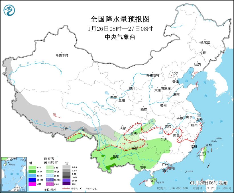
From 08: 00 on January 26 to 08: 00 on January 27, there was light snow or sleet in parts of western mountainous areas of southern Xinjiang, western and southern Tibet, southeastern Sichuan Basin, northwestern Guizhou and northern Yunnan, and there was moderate to heavy snow (5 ~ 7 mm) in the local area. There are small to moderate rains in parts of central and southern Yunnan, southern Guizhou, southern Hunan, northern and western South China. There are 4 ~ 6 winds in parts of Liaodong Peninsula, north-central Tibet and Shandong Peninsula (see Figure 1). There will be 5~7 winds and 8 gusts in the northeastern and southwestern waters of the East China Sea, Taiwan Province Strait, most of the South China Sea and Qiongzhou Strait.

Figure 1 National Precipitation Forecast Chart (08: 00 January 26-08: 00 January 27)
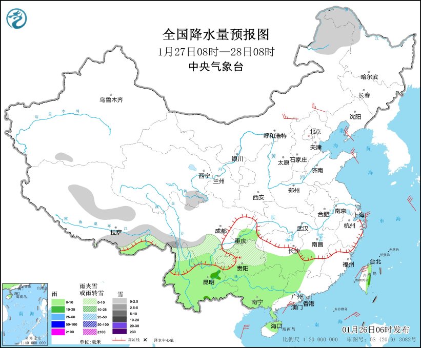
From 08: 00 on January 27 to 08: 00 on January 28, there were small to medium snow or sleet in parts of northeastern Inner Mongolia, northwestern Heilongjiang, north-central and southeastern Tibet, southern Qinghai, northern Sichuan Plateau, northern Yunnan and northwestern Guizhou. There are small to moderate rains in parts of southeastern Tibet, southeastern Southwest China, western and northern South China, southwestern Jiangnan and Taiwan Province Island. There are 4 ~ 5 winds in parts of central Inner Mongolia, Liaodong Peninsula and Shandong Peninsula (see Figure 2). There will be 5~7 winds in the northeastern and southwestern seas of the East China Sea, Taiwan Province Strait and Qiongzhou Strait.

Figure 2 National Precipitation Forecast Chart (08: 00 January 27-08: 00 January 28)
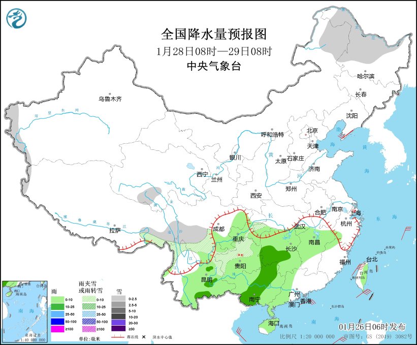
From 08: 00 on January 28 to 08: 00 on January 29, there was light snow or sleet in parts of northeastern Inner Mongolia, northern Heilongjiang, western mountainous areas of southern Xinjiang, eastern Tibet, southern Qinghai and western Sichuan Plateau. There are small to moderate rains in parts of the eastern and southern parts of Southwest China, the central and western parts of Jiangnan, and the central and western parts of South China. There are 4 ~ 5 winds in parts of Liaodong Peninsula and other places (see Figure 3). There will be 5~7 winds in the northeastern part of the East China Sea, Taiwan Province Strait and Qiongzhou Strait.

Figure 3 National Precipitation Forecast Chart (08: 00 January 28-08: 00 January 29)
(Editor: Zhang Lin)