CCTV News:According to the website of the Central Meteorological Observatory, today (September 25), due to the tropical depression in the South China Sea, rainy weather occurred in Hainan and other places. It is estimated that there will be a risk of rainstorm disaster in the eastern part of Hainan in the next three days, and it is recommended to do a good job in secondary disaster prevention; There is rain and snow cooling weather in northern Xinjiang, so we should pay attention to the impact on traffic, urban operation and agriculture and animal husbandry. In addition, the risk of continuous rain in autumn harvest in the eastern part of northwest China, southern Henan, Hubei and Guizhou is high, so it is suggested to seize the gap between precipitation and harvest mature crops.
First, the weather situation
Rainy weather in Hainan and other places: today, due to the tropical depression in the South China Sea, moderate to heavy rain occurred in parts of northern and eastern Hainan Island, and local heavy rains occurred in Qionghai and Wenchang; There are 6 ~ 8 gusts along the coast of Guangdong and Hainan Island. In addition, due to the influence of cold air, there are 6 ~ 8 grades and 9 local gusts in eastern Xinjiang, Inner Mongolia, western Heilongjiang and western Jilin.
Second, the key weather forecast
(1) There is heavy precipitation in Hainan Island.
Affected by the tropical depression in the South China Sea, there will be heavy rains (100-180 mm) in Hainan Island, Sansha City, Leizhou Peninsula in Guangdong and Guangxi coastal areas from 25th to 26th. The low pressure will move to the northwest at a speed of 20-25 kilometers per hour, with little change in intensity. It will land on the central coast of Vietnam on the night of the 25th (tropical low pressure, magnitude 6-7, 12-14m/s), and then gradually weaken.
(2) There are many cold air activities in Northeast Inner Mongolia and other places
From the night of 25th to 27th, due to the influence of cold air activities, the temperature in most parts of Inner Mongolia and Northeast China dropped by 4 ~ 6℃, and the local temperature in western Inner Mongolia dropped by more than 8℃, accompanied by 4 ~ 6 winds and gusts of 7~9, and there was sand blowing in the central and eastern Inner Mongolia. There are small to moderate rains and local heavy rains in northern Xinjiang, northeastern Inner Mongolia, Heilongjiang and other places, and there is sleet or snow in Altay Mountain area of Xinjiang.
From 26th to 29th, affected by a new round of cold air activities, the temperature in northern Xinjiang, Inner Mongolia and Northeast China dropped by 4~6℃, and the local temperature dropped by more than 8℃, accompanied by 4 ~ 6 winds.
(3) It is rainy in West China.
In the next three days, there will still be rainy weather in West China, with moderate to heavy rain and local heavy rain in parts of southern Gansu, northeastern Sichuan, Chongqing, southwestern Shaanxi and western Hubei.
Third, the specific forecast for the next three days
From 20: 00 on September 25 to 20: 00 on September 26, there were moderate to heavy rains in parts of southwestern Guangdong, southwestern Guangxi, Hainan Island, northern Xinjiang, southeastern Tibet, and southwestern Shaanxi. Among them, there were heavy rains or heavy rains (100-180 mm) in parts of eastern and southern Hainan Island. In addition, there is sleet or snow in Altay mountain area of Xinjiang. There are 4 ~ 6 winds in parts of central and western Inner Mongolia and Shandong Peninsula (see Figure 1).
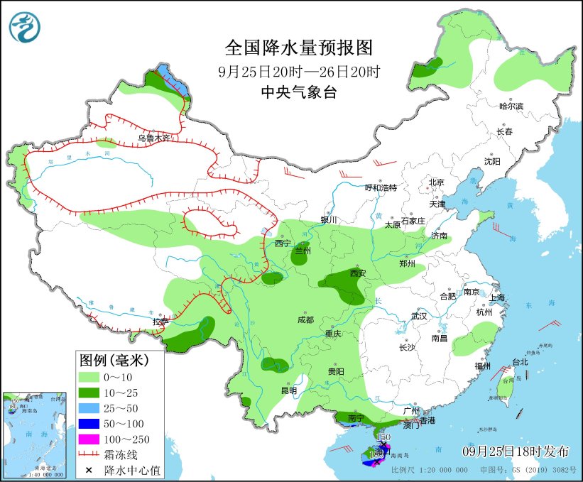
Figure 1 National Precipitation Forecast Chart (from 20: 00 on September 25th to 20: 00 on September 26th)
From 20: 00 on September 26 to 20: 00 on September 27, there were moderate to heavy rains in parts of northern Heilongjiang, northeastern Inner Mongolia, eastern Xinjiang, central Gansu, southwestern Shaanxi, southwestern Shanxi, northeastern and southern Sichuan Basin, southern Yunnan, Hainan Island and southern Tibet. Among them, there were heavy rains (50-60 mm) in parts of southeastern Hainan Island. There are 4 ~ 6 winds in parts of northern and central Inner Mongolia, most of Northeast China and southeastern Hainan Island (see Figure 2).
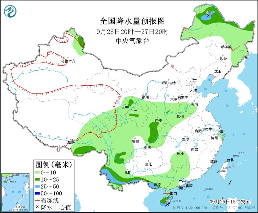
Figure 2 National Precipitation Forecast Chart (from 20: 00 on September 26th to 20: 00 on September 27th)
From 20: 00 on September 27 to 20: 00 on September 28, there were moderate to heavy rains in parts of northern Heilongjiang, southwestern Gansu, southwestern Shaanxi, northeastern Sichuan, most of Chongqing, western Yunnan, coastal areas of Guangdong, Hainan Island and southern Tibet. Among them, there were heavy rains (50-60 mm) in parts of northwestern Chongqing. There are 4 ~ 6 winds in parts of central and northern Inner Mongolia, most of Northeast China and Shandong Peninsula (see Figure 3).
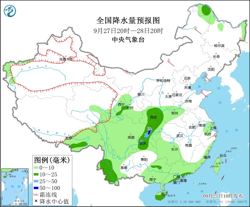
Figure 3 National Precipitation Forecast Chart (20: 00 on September 27th-20: 00 on September 28th)